
POLICY LL8: Green and Blue Infrastructure
The Neighbourhood Plan identifies the Bedfordshire Local Nature Recovery Strategy Network and the Leighton Linslade Green and Blue Infrastructure Plan (GBI) (Appendix F) for the purposes of applying National Decision-Making Policy N2 on using green infrastructure to secure multiple benefits and minimise impacts on biodiversity. This GBI Plan provides additional local detail to help inform delivery of the priorities identified within the Bedfordshire Local Nature Recovery Strategy (published December 2025)
- Development proposals that lie within or adjoining identified locations in the Leighton Linslade Green and Blue Infrastructure Plan are required to have full regard to creating, maintaining and improving the functionality of those locations in the design of their layouts, landscaping schemes and public open space provisions.
- Where statutory BNG is required, every effort should be made to deliver this on-site. Where this is not possible, off-site biodiversity gains should be delivered as close to the development site as possible.
- Proposals for new development requiring the provision of on-site open space will be supported where the design of open space is integral to the scheme and is effectively connected to any adjoining green infrastructure assets. Proposals within built up and previously developed areas of Leighton Linslade will be required, wherever possible, to create new natural green spaces within their schemes, providing benefits for wildlife and people, particularly where there are existing greenspace deficits. Where appropriate, developers will be expected to enter into a planning obligation to secure satisfactory arrangements for the long-term management of such open spaces.
- The Leighton Linslade Green and Blue Infrastructure Plan identifies Strategic Landscape Opportunity Areas, Biodiversity Opportunity Areas, Historic Environment Opportunities, Blue Infrastructure Opportunities and GBI priority projects which will be supported.
The Network has been produced and mapped by Bedfordshire and Luton Biodiversity Recording and Monitoring Centre (BRMC), the Greensand Trust and Natural England. It illustrates existing biodiversity interest and opportunities where biodiversity enhancement would make the greatest, most effective contribution to nature recovery over the next 5-10 years, in line with Bedfordshire Local Nature Recovery Strategy and local aspirations. This takes account of the section 104 of the Environment Act 2021 that relates to all or part of the neighbourhood plan area.
Green and Blue Infrastructure is a term that covers a wide range of ecological and often biodiverse features. The Network comprises assets of high nature conservation value including rare and threatened heathland habitats, wildflower rich meadows, ancient semi-natural and secondary woodland, trees, hedgerows and water bodies – all assets of high biodiversity value. Also included are those areas of recreation and amenity value including children’s play areas and play spaces, allotments, recreational playing fields, and off street footways and cycleways in and around Leighton Linslade. In most cases assets have multi-functional, nature conservation, recreational and amenity value.
In areas such as Leighton Linslade, mapping this rich ecological value, does not just illustrate where they are currently located, but also points to where the network may be improved to be better connected if or when land is developed or redeveloped.
Green and blue infrastructure performs a vital public health function alongside their environmental role. They provide accessible places for everyday physical activity, informal recreation and active travel, helping to reduce sedentary behaviour and support cardiovascular health across all age groups. Equally important are their benefits for mental health and wellbeing: access to nature has been shown to reduce stress, anxiety and social isolation, improve mood and support cognitive development in children and young people. Blue infrastructure, including rivers, canals and wetlands, contributes to these outcomes while also playing a preventative health role through cooling urban areas, improving air quality and managing flood risk, thereby reducing heat-related illness and wider environmental health impacts.
Developers are recommended to utilise the Natural England Green Infrastructure Framework (GIF) in preparation of proposals and incorporate use of GI standards within design codes.
It is noted that the Neighbourhood Plan does not set biodiversity targets as this is a function of the Bedfordshire Natural Recovery Strategy but it is noted that the LNRS recognises that Bedfordshire is one of the most nature depleted counties in the UK.
In addition to the projects detailed in the policy, the Neighbourhood Plan highlights the following wider Green and Blue Infrastructure recommendations:
- Continue to work with CBC to develop and expand road verge management that supports biodiversity, with ‘cut and collect’ regimes timed to benefit appropriate flowering species.
- Encourage tree and woodland creation and hedgerow planting where this enhances connectivity and buffering of existing woodlands and does not compromise other habitat objectives.
- The encouragement of BNG registration of land within the parish by a range of partners and landowners, ensuring that locally suitable and beneficial options for BNG receptor sites are available to developers.
- Targeted control of invasive non-native species where these are having an impact on local biodiversity.
- Work with the Environment Agency, IDB, UBOCP and others (including adjacent parishes) to target Natural Flood Management delivery where it will have the greatest impact in flood risk reduction, while also delivering benefits for nature.
- Ensure any new infrastructure created to reduce flood risk in the parish (including any new reservoirs) delivers multiple benefits for biodiversity, access and recreation.
- Continue to support local ‘Citizen Science’ activity which contributes knowledge of the GBI network, identifies issues and monitors species, habitats and projects
In respect of Clause B, Leighton Linslade Town Council is working with the Greensand Trust and the wider community to undertake a parish wide biodiversity and ecology survey of around 20 sites between April-September this year. After the survey window closes in September the results will be analysed and a more detailed biodiversity action plan with recommendations will put forward to committee/council with a view to identifying more local BNG opportunity sites as currently off-site credits are being used some distance outside of the parish.
Leighton Linslade Green and Blue Infrastructure Network Policy Map
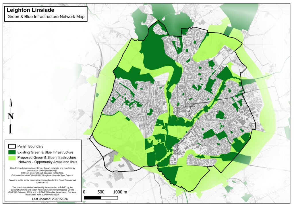
The Green and Blue Infrastructure Map is only available as a pdf. To see the full Leighton-Linslade Neighbourhood Plan Policy Map, please visit our Policy Map page.